

FlightX - Airport Finder & Flight Plan Calculator

คำอธิบายของFlightX - Airport Finder & Flight Plan Calculator
FlightX is a flight planning tool with an extensive worldwide airfield / airport listing.
It's an ideal application for VFR Pilots to plan a successful trip and cross reference other flight planning calculations.
Create Flight Plans
Find airports and airfields by code, description, or part thereof
Enables the user to create a flight plan
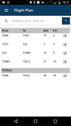
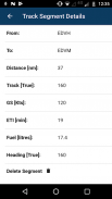
Calculate flight distance, flight times and track information for each flight segment and totals for a multi-stop flight plan
Provide information on airfields such as elevation, latitude, longitude
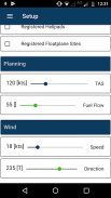
Calculate fuel burn based on burn rate specified
Heading information taking into account specified wind information
Calculating wind correction
The app will adjust existing flight plan calculation if any factor affecting these is adjusted
Find airports, airfields and other information
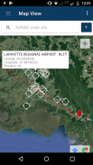
The app can switch between a map view, satellite view, or hybrid view to display flight information.
Flight plan information can be created visually on a map (click the info window), or via the automatic airport / airfield finder lookup. Simply start typing and the app will provide the best match to your search.
Additionally the app can search for closed airfield, registered heliports, seaplane port.
Particularly useful is the feature where the app can find all airfields / airports within a geographical region. Simply zoom in or out on the map, and select Find All Airfields on Map.
Note: that for the Australian region the app also can find VFR waypoints as registered in the EnRouteSupplement.
The app comes with a 30-day trial period, after which time an annual subscription can be purchased through the Google Play Store.
Developed by pilots for pilots.
FlightX เป็นเครื่องมือในการวางแผนการบินที่มีรายชื่อสนามบิน / สนามบินทั่วโลกอย่างกว้างขวาง
เป็นแอพพลิเคชั่นที่เหมาะสำหรับนักบิน VFR ในการวางแผนการเดินทางที่ประสบความสำเร็จ
สร้างแผนเที่ยวบิน
ค้นหาสนามบินและสนามบินตามรหัสคำอธิบายหรือส่วนหนึ่งส่วนใด
ช่วยให้ผู้ใช้สามารถสร้างแผนการบิน
คำนวณระยะทางเที่ยวบินเวลาเที่ยวบินและข้อมูลการติดตามสำหรับแต่ละส่วนเที่ยวบินและยอดรวมสำหรับแผนเที่ยวบินแบบหลายหยุด
ให้ข้อมูลเกี่ยวกับสนามบินเช่นระดับความสูง, ละติจูด, ลองจิจูด
คำนวณการเผาผลาญเชื้อเพลิงตามอัตราการเผาไหม้ที่ระบุ
ข้อมูลส่วนหัวโดยคำนึงถึงข้อมูลลมที่ระบุไว้
การคำนวณการแก้ไขลม
แอปจะปรับการคำนวณแผนเที่ยวบินที่มีอยู่หากปัจจัยใด ๆ ที่มีผลต่อสิ่งเหล่านี้ถูกปรับ
ค้นหาสนามบินสนามบินและข้อมูลอื่น ๆ
แอปสามารถสลับระหว่างมุมมองแผนที่มุมมองดาวเทียมหรือมุมมองไฮบริดเพื่อแสดงข้อมูลเที่ยวบิน
สามารถสร้างข้อมูลแผนเที่ยวบินได้บนแผนที่ (คลิกที่หน้าต่างข้อมูล) หรือค้นหาค้นหาสนามบิน / สนามบินอัตโนมัติ เพียงเริ่มพิมพ์และแอปจะให้สิ่งที่เหมาะกับการค้นหาของคุณมากที่สุด
นอกจากนี้แอปสามารถค้นหาสนามบินปิดลานจอดเฮลิคอปเตอร์ลงทะเบียนพอร์ตเครื่องบิน
มีประโยชน์อย่างยิ่งคือฟีเจอร์ที่แอปสามารถค้นหาสนามบิน / สนามบินทั้งหมดภายในภูมิภาคทางภูมิศาสตร์ เพียงซูมเข้าหรือออกบนแผนที่และเลือก ค้นหาสนามบินทั้งหมดบนแผนที่
หมายเหตุ: สำหรับภูมิภาคออสเตรเลียแอปนี้ยังสามารถค้นหาจุด VFR ตามที่ลงทะเบียนไว้ ใน EnRouteSupplement
แอพนี้มีระยะเวลาทดลองใช้ 30 วันหลังจากนั้นสามารถสมัครสมาชิกรายปีผ่าน Google Play Store ได้
พัฒนาโดยนักบินเพื่อนักบิน


